
Since the weather has not been the best here in the last week. I made up my mind it was time get the Lycra skinsuit on and use my indoor cycle trainer.
Wetsuit snow fun photos : 19/01/2013
Since I have not done any fun photos in the snow since 2009. I made up my mind it was about time I took some more. I hope you all like these photos of myself wearing the blueseventy axium wetsuit with the RST Delta Gloves. Can’t wait to read your comments about them!!


Here are some cycling and wetsuit snow photos
Since it’s snowing in more parts of the UK. It’s a good good time to look back at some snow photos :).


More photos like this can be found @ www.gordon-valentine.com/zenphoto/page/search/tags/snow.
Glasgow Police Box
I love this photos of myself taken next to a Police Box in Glasgow, near the junction of Cathedral Street and High Street.

Check out www.policeboxes.co.uk/police-boxes-today.html to see where other Police Box are in Glasgow and the rest of the UK.
No longer be able to collect or spend points with Amazon.co.uk
![]() Looks like, I will no longer be shopping with Amazon.co.uk. I only use to buy things from them so I would also get Nectar points. So I will need to find somewhere else to buy my music and tech stuff from.
Looks like, I will no longer be shopping with Amazon.co.uk. I only use to buy things from them so I would also get Nectar points. So I will need to find somewhere else to buy my music and tech stuff from.
“Dear Gordon,
As you have collected Nectar points with Amazon.co.uk via eShops or redeemed points for an Amazon.co.uk Gift Certificate in the past, we are writing to let you know that after 31st January 2013 you will no longer be able to collect or spend points with Amazon.co.uk.
But don’t despair, there are still hundreds of other ways to collect and redeem your Nectar points. A few of our favourites are below, or click here to see them all.
Thank you,
The Nectar Team”
Latest cycling news (Radio Five Live) : 14/01/2013
![]()
If you love cycling. You will not want to miss tonight’s Cycling show on BBC Radio Five Live. It start at 9:00pm GMT. It’s got the latest cycling news ahead of Lance Armstrong’s interview with Oprah Winfrey.
If you miss the show it will be on the BBC iPlayer at www.bbc.co.uk/programmes/b01qct1m.
Just renewed endtoend-cycle.com
 I am sure that most of you will know that I cycled from John O’Groats to Land’s End (JOGLE) way back in August 2009. I have just renewed the domain for the website went with the cycle for another 3 years. At a cost of £46.96 and that’s with a 10% off.
If you have never checked out my End to End cycle website, please do so!!
MSN to close 15th March 2013
![]() I am sure that most of you will know by now that MSN closes on 15th March. If you already have me on MSN, please re-add me to your Skype account. I use the same username on both. Just Skype does have not the “@yahoo.com” bit at the end of it.
I am sure that most of you will know by now that MSN closes on 15th March. If you already have me on MSN, please re-add me to your Skype account. I use the same username on both. Just Skype does have not the “@yahoo.com” bit at the end of it.
Moving to a new server (9th January 2013)
![]() I got the following email from my host last week.
I got the following email from my host last week.
“As part of an ongoing programme to improve the service we deliver to you, we will be migrating your professional hosting account for gordon-valentine.com from the server currently powering it to a more powerful, up to date server.
As part of this move, Plesk will no longer be involved as the control panel on your server and all changes to your account can be made through our control panel.
Your website will be unavailable for up to an hour next Wednesday 9th January 2013.
E-mail will not be affected during this move.”
So when you can’t access this website for a number of hours today at some point you know why.
08-Jan-2013 : Third cycle of 2013!
Now done my third cycle of 2013. You may have noticed I have been posting every cycle route of the year so far. The aim is, I will do a post about every cycle over 20 miles. Does mean, I will need to try to do lots of different routes. If I don’t, you will get bored of seeing much the same maps all the time!
I will now leave you with the route map, elevation graph and route statistics.
Route map:-

Elevation graph:–
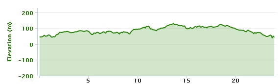
Route statistics:-
- Distance: 23.96 miles.
- Time: 1:57:29 (h:m:s).
- Avg Speed: 12.2 mph.
- Max Speed: 36.1 mph.
- Elevation Gain: 244 meters.
- Min Elevation: 38 meters.
- Max Elevation: 129 meters.
Data from: Garmin Connect.